
Hike through the rolling hills and valleys of the Yorkshire Dales National Park.
Follow riverside paths between idyllic Yorkshire villages and classic English market towns.
Stay in traditional inns and farmhouses dating from the 16th and 17th Centuries.
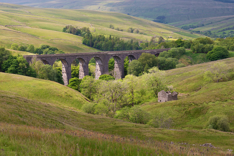
Discover the historic Bolton Abbey, Hubberholme Church and the Settle-Carlisle railway line viaducts.
Refresh yourself in classic English country pubs along the way.
Self-guided hike on the Dales Way
A 125 km walk crossing the Pennines from Ilkley to Bowness on Windermere.
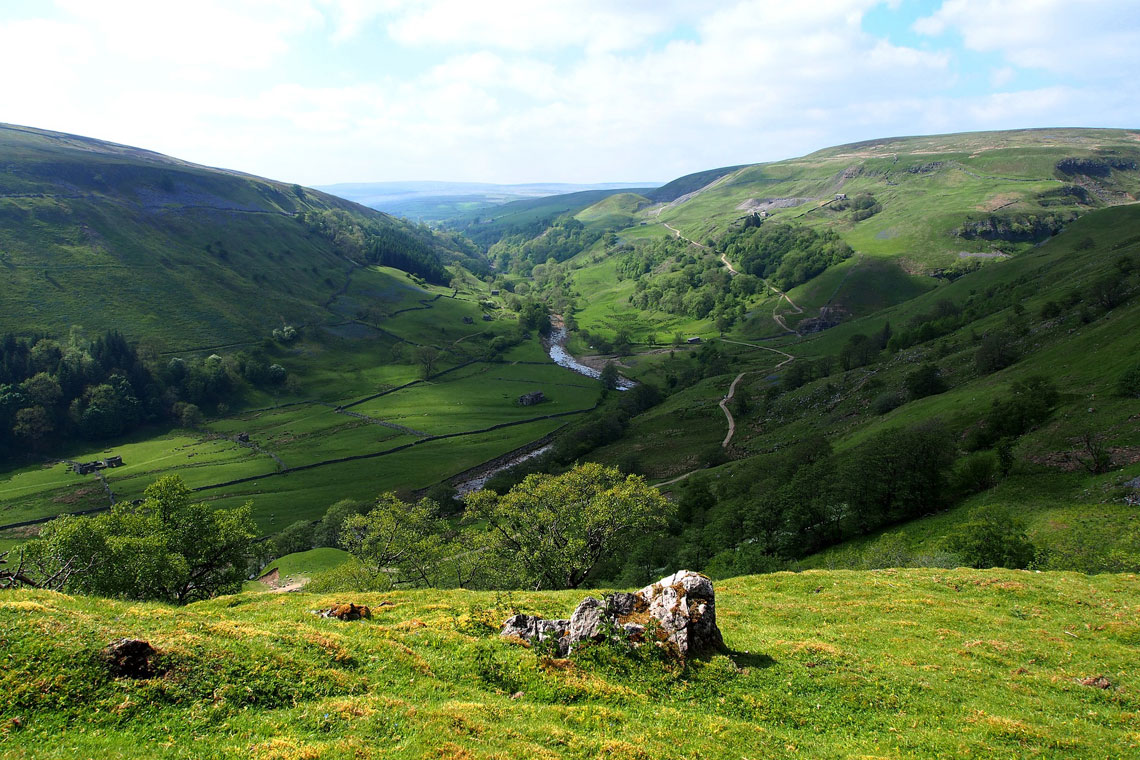
Welcome to the beautiful Yorkshire Dales, the purest form of English highland landscape, with traditions and scenery which have remained virtually untouched for centuries. Soft rolling hills, lush green valleys, waterfalls, Roman roads, historic churches, an Augustinian abbey and some lovely Real Ale pubs all await you on this week-long walking holiday.
The Dales Way crosses two National Parks, containing some of the best-known walking territory in Britain and some of England’s most scenic landscapes. This tour includes the whole 125 km length of this much-loved long-distance path, established in 1969, which runs right across the Yorkshire Dales National Park to the Lake District.
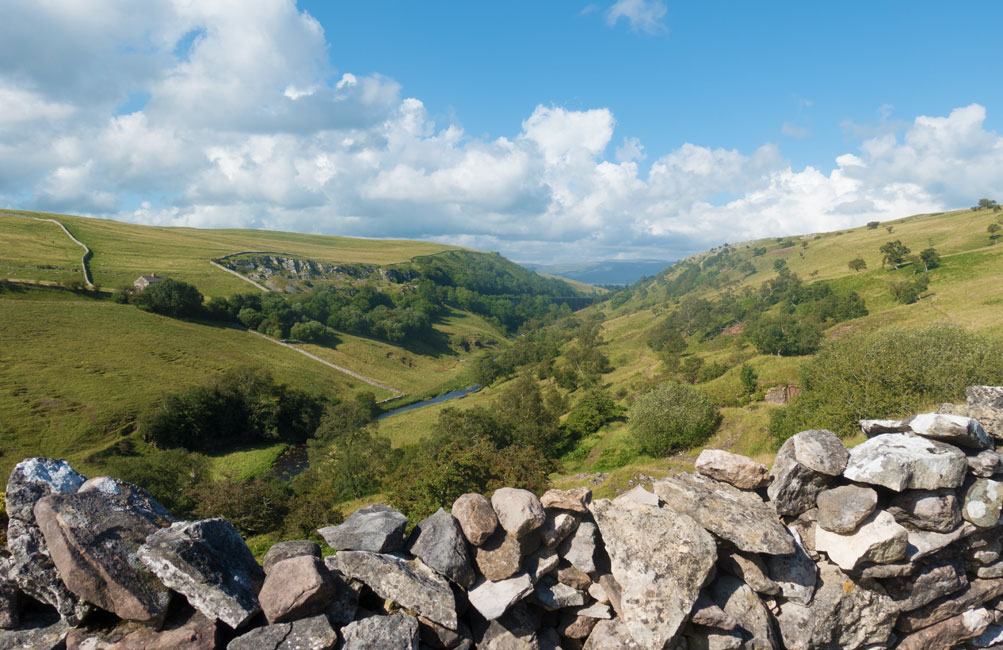
Much of the trail follows pretty valleys along the Rivers Wharfe, Dee, Rawthey, Lune and Kent. All have numerous beauty spots for shady picnics. The small ravines and rapids and are patrolled by birds such as Berwick swans, kingfishers, dippers and wagtails. Brown trout lurk in their waters.
The Dales Way leads first through the Wharfedale valley, perhaps the prettiest of the Yorkshire Dales. A particular highlight here is the ruined Augustinian Bolton Priory. You follow scenic riverside paths between the charming, cobbled villages of Burnsall, Buckden, Grassington and Kettlewell. Continuing via Hubberholme, you gradually gain height as you make your way upstream to reach the Pennine watershed at Cam Fell (520 m). The way then descends through Dentdale to the old market town of Sedbergh and finally across sheep pastures to Bowness on the shore of Lake Windermere.
| 8 DAYS / 7 NIGHTS | From €970 per person sharing*
*A single supplement charge will apply for solo walkers. |
||||||||||||
| ACCOMMODATION |
We use a variety of accommodation along the route ranging from bed and breakfasts to lodges, pubs and small hotels. They are run by walker friendly hosts offering en-suite or private facility rooms with a tasty breakfast to get you ready for the walk ahead. Further facilities such as washing and drying facilities, packed lunches and packed lunches are available in some accommodations. | ||||||||||||
| MEALS | The overnight accommodations are on a bed & breakfast basis. You will have a selection of cold and hot options to choose from each morning.
Packed lunches can be booked and paid for on arrival at your accommodation. They offer a good selection of sandwiches, snacks and drinks for you to take with you for that day’s walk. On a few sections you will also pass a café and/or shop but on many days you will not pass anything between the start and finish. For evening meals you will have a variety of pubs and restaurants to choose from, or your accommodation will provide a tasty meal. |
||||||||||||
| AVAILABILITY | You can start any day, subject to availability, between April and mid-October. | ||||||||||||
| INCLUDED |
|
||||||||||||
| NOT INCLUDED |
|
||||||||||||
| OPTIONAL EXTRAS |
|
||||||||||||
| DIFFICULTY / TERRAIN | The difficulty level of this tour is rated as moderate overall. The gradients and terrain are generally straight forward, but the going may be muddy underfoot in wet weather; there are some high moorland areas to cross. There are also a large number of “stiles” and “kissing gates” to negotiate as you stroll across fields, so good mobility is important. The walks are mostly unsurfaced tracks, riverside paths, mountain trails and some short stretches on tarmac roads. | ||||||||||||
Day 1: Arrival in Ilkley, West Yorkshire
Arrival in the pleasant market town of Ilkley, which is just a short train ride from Leeds (30 mins approx.) Public transport routes are available from all major airports (via Leeds). Transfers can also be arranged from Leeds/Bradford Airport and Manchester Airport.
If you arrive early, you can do an optional walk to the Cow & Calf Rocks and Ilkley Moor. Here you can find the ‘White Well’; a tiny Victorian spa (not much bigger than a luxury sized bath) which was popular in the days when people with pneumonia were encouraged to bathe in icy cold waters. If the flag is flying, a small teashop is also open (2.5 hr round trip). If you prefer to relax, then you can have a look around this attractive country town with its range of specialist local family shops and cafes. There is a branch of Betty’s Tea Rooms with delicious cakes and a variety of teas. There is also a small history museum and next to it the All Saints Church, which is built on the site of a Roman fort and contains Anglo-Saxon crosses dating back to the 9th century.
Overnight: Ilkley.
Day 2: Ilkley to Burnsall
Distance: 21 km | Ascent: 223 m | Descent: 164 m | 4½ hrs approx.
This is a very beautiful walk which follows the River Wharfe upstream from the lowland scenery of Lower Wharfedale to the hilly surroundings of the Dales. The well-preserved remains of Bolton Abbey Augustinian Priory are a highlight on today’s route. From the Priory, you can cross to the other side of the Wharfe either by the bridge or by a long sequence of steppingstones. The route continues through the Duke of Devonshire’s estate and into beautiful Strid Woods.
Thirsty people with an interest in architecture might like to take mile or so detour to the pretty village of Appletreewick, which has an interesting ensemble of local stone houses as well as two nice pubs. Your accommodation for tonight is in the idyllic riverside village of Burnsall. There are a couple of interesting churches including St. Wilfrid’s from the 1400s.
Overnight: Burnsall.
Day 3: Burnsall to Hubberholme/Cray
Distance: 25 km | Ascent: 320 m | Descent: 224 m | 5½ hrs approx.
Today’s route is a mix of upland and lowland walking. You first follow the Wharfe past attractive Linton to the market town of Grassington, with is cobbled streets and teashops. The route then leaves the river and climbs to higher ground, leading across upland fields fringed with drystone walls. Look out for Conistone Pie, a limestone hill feature which looks like a pie! You will enjoy great views over rocky scars, dales and limestone pavements before descending again to the river as you reach the old lead mining village of Kettlewell, with three pretty looking pubs. Re-joining the river, you then thread your way through sheep-filled fields to the even smaller village of Buckden. Here, you can take a rest on the green or maybe have a drink before the final mile into the pretty riverside village of Hubberholme. If you are not staying here, you will be making a 2 km diversion off the official route to Cray, a tiny hamlet over the hill.
Overnight: Hubberholme/Cray.
Day 4: Hubberholme to Cowgill
Distance: 22.5 km | Ascent: 407 m | Descent: 361 m | 5 hrs approx.
Enjoy a hardy breakfast as today is your most challenging walk. The route follows the River Wharfe towards its upper youthful sections, its water spilling off limestone terraces and small waterfalls.
You first pass Hubberholme with its attractive church and torrents. Next, look out for the tiny stone circle at Yockenthwaite. Further along at Beckermonds, you reach the source of the Wharfe from two small becks or streams. Saying goodbye to the infant river here, you climb stiffly up and out of Wharfedale over Cam Fell. The farmland here can be boggy! A steep ascent from Cam houses, the last farm in the Dale, brings you to a broad track and the highest point of the walk at 521m. You then start descending along what was once a Roman road, cutting across the Pennine Way Footpath and down into Dentdale. In clear weather you will enjoy views of the Yorkshire Three Peaks; Penyghent, Whernside and Ingelborough.
You continue down towards Ribblehead through a further moorland section before re-ascending slightly to cross over to Denthead. Here, you are confronted with the magnificent viaduct on the Settle to Carlisle Railway, which almost seems to be a natural part of the surroundings. Another mile of steep descent along the pretty River Dee brings you to Cowgill. This is a pretty and tranquil place. There are occasional cars, but you are more likely to be awoken by the sound of owls, sheep and the babbling river.
Overnight: Cowgill.
Day 5: Cowgill to Sedbergh
Distance: 17.5 km | Ascent: 182 m | Descent: 336 m | 4½ hrs approx.
A very pleasant walking day through the Dentdale valley. You will follow the course of the River Dee, which becomes wider and wilder as you go. A stop in the village of Dent is recommended; a lovely Dales village with a narrow, cobbled main street, white-walled cottages and an ancient village church.There are a couple of welcome tea shops and the George and Dragon pub serves ale crafted by the Dent Brewery only a couple of miles away.
Following the river some more, you ascend over a slight ridge and then down into Garsdale before crossing the river Rawthey and ascending steeply to the small town of Sedbergh at the foot of the steep Howgill Fells. Sedbergh is known as ‘England’s Book Town’ and has an overwhelming number of bookshops – worth knowing if you are out of reading material by this stage of your trip!
Overnight: Sedbergh.
Day 6: Sedbergh to Burneside
Distance: 25 km | Ascent: 272 m | Descent: 347 m | 5½ hrs approx.
Leaving Sedbergh along the River Rawthey, you then turn north to follow the River Lune to Beck Foot. You will pass some more viaducts from the glorious Victorian era of engineering. At Crook of Lune you will discover a beautiful parabolic arch bridge, which is probably 500 years old. The view from it towards the Howgill Fells is a beauty.
The Dales Way then turns westward towards the Lake District, across an undulating landscape of sheep pastures with lovely views of the Howgills. You will reach Black Moss Tarn, a tiny lake tucked into a fold of the meadows, often with swans and geese floating upon it. This is a good spot for a break before descending to cross the River Sprint and then onwards towards the 14th Century Burneside Hall, a pele tower which was built to protect against Scottish border raiders. You finally arrive in the village of Burneside, dominated by its paper mill on the banks of the River Kent.
Overnight: Burneside.
Day 7: Burneside to Bowness on Windermere
Distance: 16 km | Ascent: 271 m | Descent: 283 m | 4 hrs approx.
After breakfast, you will be transferred back to Burneside to continue your walk.
This morning you follow the attractive River Kent to Staveley. You will pass lots of interesting former mills, some of which have been creatively converted into housing. The millponds still remain and often trout can be seen jumping for fly. Staveley is an attractive village, worth a coffee stop with its interesting bell tower.
The walk then becomes increasingly rural and the scenery more rugged and rocky. On a good day a short diversion up to School Knott will reveal a great Lakeland panorama including the Coniston Fells, Crinkle Crags and Scafell. You finally descend towards Lake Windermere, which remains elusive until you emerge from the woodland above Bowness on Windermere, a pleasant tourist town on the lakeside. Bowness is the most popular visitor destination on Lake Windermere, England’s largest natural lake.
Overnight: Bowness on Windermere.
Day 8: Departure from Bowness
Your arrangement ends after breakfast this morning.
*Walking distances may vary depending on accommodation available.
Getting to Ilkley
Getting from Bowness on Windermere


Tour Reviews
We had very seamless and wonderful time on our trip. The Wild Rover team did an excellent job, with great customer service, accommodations and support along the way. We had only one snafu that was immediately rectified by the company – again speaking to the customer service. The hike itself was relaxing most of the time, taxing at others and filled with beauty the entire time. Thank you!
Leave a Review